


Cross-Strait relations in the Lai era
On May 20, Lai Ching-te was inaugurated as Taiwan's new president, prompting significant military...
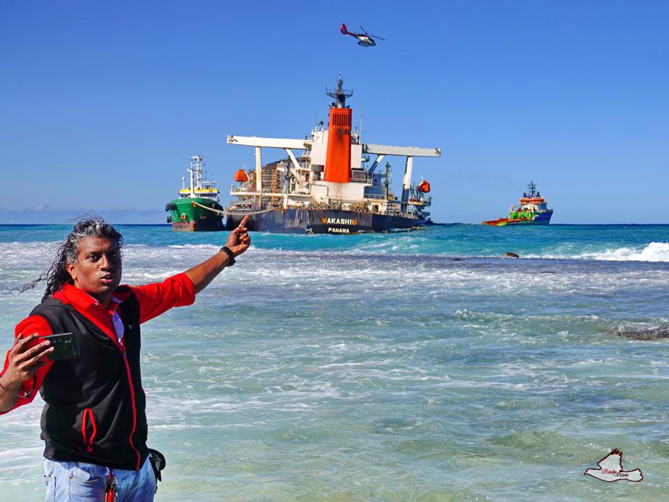
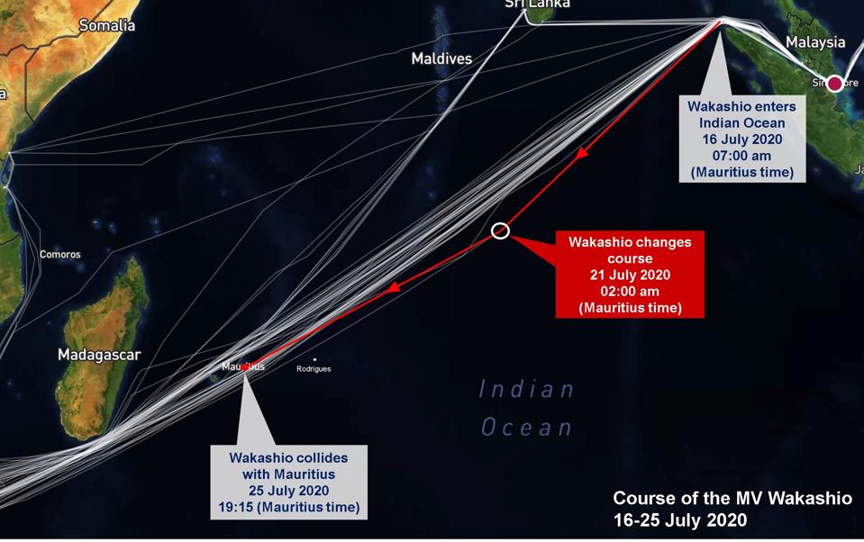
The latest set of satellite assessments is shedding new light into the cause of the Wakashio oil spill in Mauritius. It shows that the key to the entire oil spill and crash investigation lies with what occurred four days before the Wakashio was grounded on the coral reefs of Mauritius.
 Understanding the events in the early morning of Tuesday 21 July 2020 at 2.00am Mauritius local time, when the massive ship was 1500 miles away from shore, will unlock the entire mystery that continues to surround the Wakashio. This was when the final fateful course correction was made, four days before the large Japanese iron ore cargo ship slammed into the coral reefs of Mauritius, unleashing the worst oil spill in the island’s history.
Just how unusual Wakashio’s trajectory was, only becomes apparent when comparing the Wakashio’s route with that of all other large ships that crossed the Indian Ocean during July and August 2020. This is why the latest analysis, which reveals serious anomalies in the Wakashio’s voyage, is so relevant to the investigation.

In particular, a deeper analysis of the change in trajectory event on July 21 will help investigators uncover the truth, amid accusations of a coveruptaking place as accounts continue to change each day and suspicions are raised about evidence tampering on the large Japanese vessel.
It was this course correction on July 21, that set the Wakashio on a direct collision course for the Indian Ocean island of Mauritius, and which no-one stopped for four straight days.
For the past few weeks, three explanations for the grounding have emerged and been debunked.
3. Alcohol theory. The third was that alcohol or a party could have been a factor. However, if that was the case, this would be a very serious offence for Japanese operator, Mitsui OSK Lines, whose global CEO and President, Junichiro Ikeda, made a personal commitment last year to Japan’s Minister of Transport, Keiichi Ishii, highlighted in MOL’s 2019 Annual Report that a strict alcohol management program was being rolled out across all vessels operated by MOL, and that he was going to personally spearhead this campaign.
This strict group-wide MOL alcohol program included rigorous staff training, support for mental health issues such as crew depression or loneliness, crew monitoring (including senior officers) and having the latest alcohol breathalyzers on board. All this was in response to a serious crash at a US Naval Base on the island of Guam in December 2018 by a MOL Cruise Ship, the Nippon Maru that reportedly involved alcohol.
So what really happened on board the Wakashio?
The first place to start is to understand the major shipping lanes of the Indian Ocean.
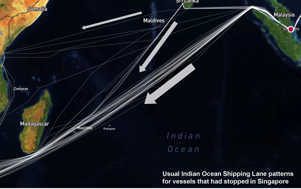
Ships follow certain pathways across the ocean. They use a system of satellites and for the past 8 years (since 2012) they have been legally required by the IMO to use electronic maps, a system called ECDIS (Electronic Chart Display and Information System). This means that there is strict precision for where a large ship is at any time, and as a result, shipping lanes are fairly tightly followed.
Using analysis from global satellite analytics firm, Windward, we can map out the pathways for all ships in the world. The chart above shows the routes taken by vessels cross the Indian Ocean, having called at the Port of Singapore and then heading South toward South Africa.
As they approach Mauritius and Reunion island, vessels either choose a Northern or a Southern path past the two islands, passing just North of Rodrigues island, an island with a population of 40,000 that has more autonomy but is part of Mauritius from a maritime security standpoint.
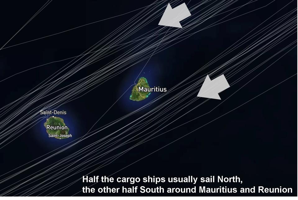
Taking the 80 vessels that left the Port of Singapore over July and August 2020 and headed toward South Africa, 40 took the Northerly route and 40 took the Southerly route.
So it is not unusual for the Wakashio to have taken the Southerly route around Mauritius.
However, it is important to notice a ‘triangle’ that extends for several hundred miles North East of Mauritius where no ships would travel into - effectively a ‘cone of protection’ around the two islands of Mauritius and Reunion. This was where the Wakashio had encroached into.
So what was unusual about the Wakashio’s trajectory was that it was on a direct collision course for Mauritius for four days, careering across busy shipping lanes, into an area that no ship had passed through for several hundred miles around Mauritius, and no-one (either on the vessel, at the shipping company headquarters, or in the Coastguard) did anything about it.
This includes why Mauritius’ air and sea rapid reaction Coastguard forces stationed on Rodrigues island were not mobilized, which could have caught up with the Wakashio and landed on the helipad on its deck.
The focal point of the entire Wakashio investigation will center on the events surrounding the 21 July 2020 maneuver at 2.00am, in the middle of the night.
In particular, answers to three important questions must be provided:
A detailed forensic analysis will be expected in the ship investigation report into the Electronic Chart Display and Information System (ECDIS), Voyage Data Recorder, the Steering and Rudder as well as a full assessment of the Engine.
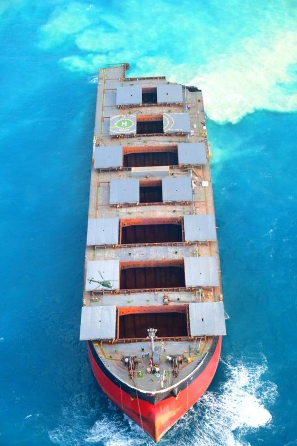
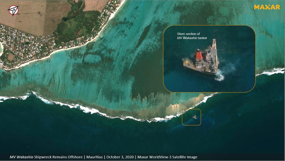
With the rear of the Wakashio that contains all the critical control, steering, navigation, communication and engine functions still in shallow waters on the reefs of Mauritius, such images and analysis should be easily obtainable before the new salvage teams arrive to dismantle this part of the ship.
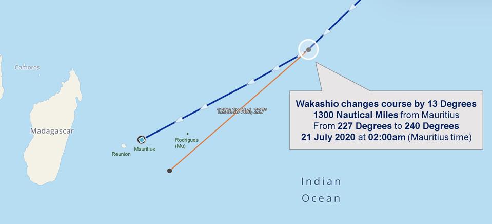
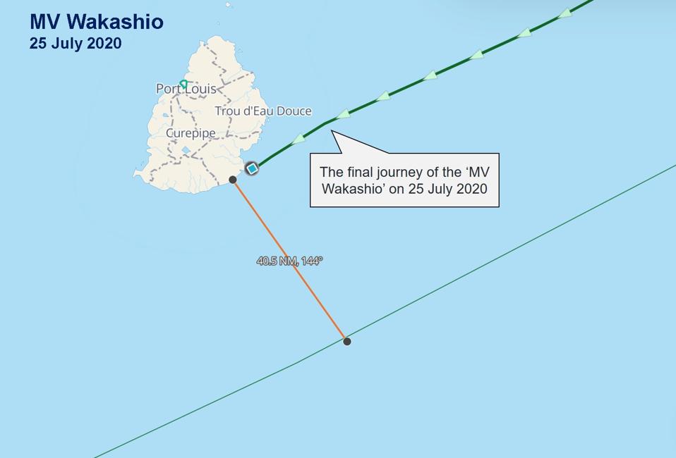
Further satellite analysis from Windward reveals that the Wakashio adjusted course 1300 nautical miles (1500 conventional miles) from Mauritius. It changed from a bearing of 227 Degrees to 240 Degrees, an adjustment of 13 Degrees from its original heading. The impact can be seen in the chart above, where the orange line marks where the Wakashio would have ended up had it not turned.
This was the fateful change that put the Wakashio on a collision course with Mauritius.
This brings us back to the question about what caused this change in trajectory.
Was it a conscious decision by the ship’s navigation team with the full knowledge of the captain? Or an accidental slip on the controls by one of the crew that was not picked up for four days? Could it have been based on a faulty map reading or a false understanding of the location and bearing of the Wakashio? Or could a software glitch be responsible for both inaccurate readings from the electronic chart as well as making the change in direction without the crew being fully aware?
This latter explanation would revive all sorts of ancient seafarer tales about ghost ships.
Important questions should also be asked about whether this was an innocent change in direction or done with any form of malicious intent.
Who was responsible technology safety on board the Wakashio on behalf of the owner and operator of the vessel? Why weren’t systems like this installed?
Digital security for modern shipping is a domain the owners and operators should have been deeply aware of, as in just two and a half months time, a whole set of new international regulations around cyber security will be made compulsory for all ships by the IMO. Both the UN shipping regulator and the Wakashio’s insurers, the Japan P&I Club, had been emphasising the importance of technology security in recent months, and insisting on compliance with the new regulations.
So the investigation does not just need to understand the mechanics of who turned the wheel to set the Wakashio into its collision course. Deeper questions need to be asked about why the crew was not aware for four days (if at all) that the vessel was heading in the wrong direction, and that there appeared to be no alerts or alarms when a collision was imminent. This was the situation for four days involving one of the biggest ships in the sea, operated by one of the world’s biggest shipping companies, Mitsui OSK Lines.
This was not a trivial oversight or ‘unfortunate accident.’
There was no ‘act of God’ unavoidable force of nature (e.g., a cyclone, tsunami, or volcano) that caused this incident, but human error in the design, operation and management of what happened. The captain of a ship cannot be the single failsafe mechanism for an entire industry that is becoming more complex, and which have tools designed to inform and oversee decisions being taken.
When the Wakashio made the turn on the 21 July, it did not just have to head to Mauritius, but would have careered across two-way traffic of the busy Indian Ocean shipping lanes.
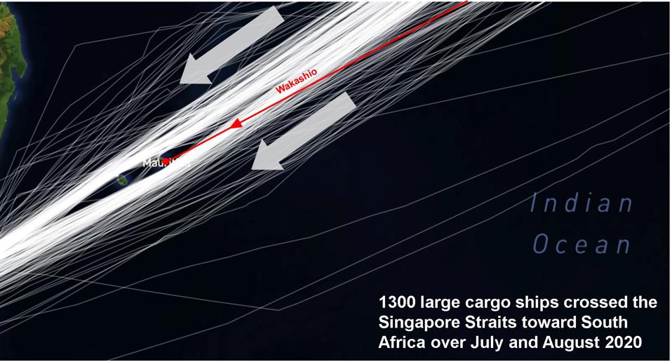
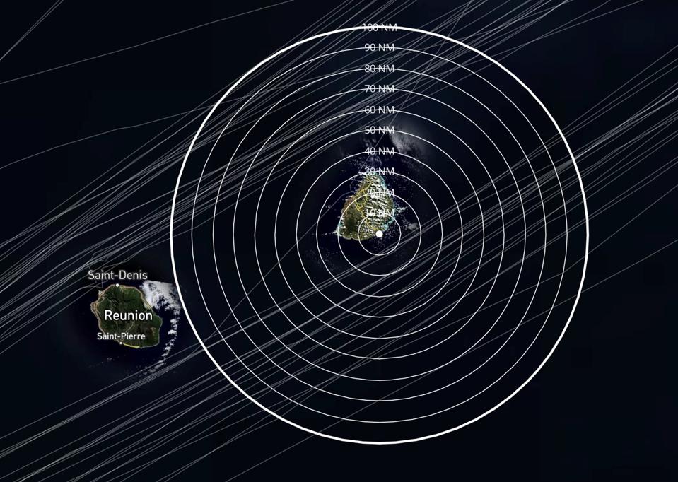
The chart above adds in not just vessels that stopped in the Port of Singapore, but all vessels that passed through the Straits of Singapore and headed in a Southerly direction. This is 1300 in two months alone, and just in the Southerly direction. Looking at ships heading in both directions, there are well over 50 large ocean-bound cargo ships a day passing by Mauritius’ coast on these busy sea lanes, day and night, an average of more than one every 30 minutes.
Travelling at a cruising speed of 11 knots, a large iron ore bulk carrier would have presented a danger to many ships across the busy Indian Ocean shipping lanes, including major oil tankers who regularly travel up and down these ocean highways.
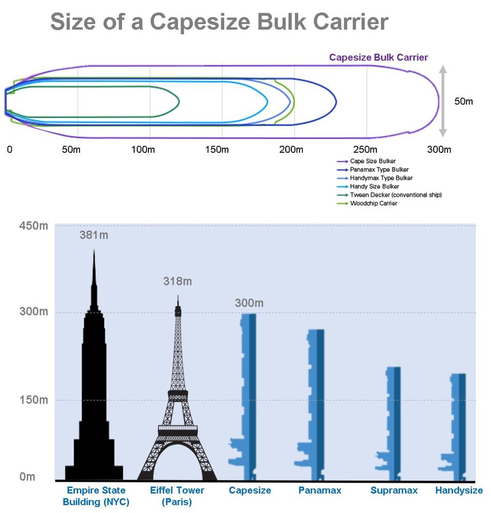
The Wakashio was a massive ship - it was too big to fit through the Suez or Panama Canals, which is why it was called Capesize. It was designed to go around South Africa’s Cape of Good Hope. If it had collided with one of the ever increasing sizes of oil tankers, the result would have been even more calamitous than it was in Mauritius, and as Sri Lanka realised when it narrowly escaped from this fate last month.
The Indian Ocean is the most important ocean for world trade. 40% of the world’s population live in countries around its rim, 50% of global container traffic, and 70% of global oil is transported across its waters. With the well known risks of piracy in the Indian Ocean, ship safety should have been paramount.
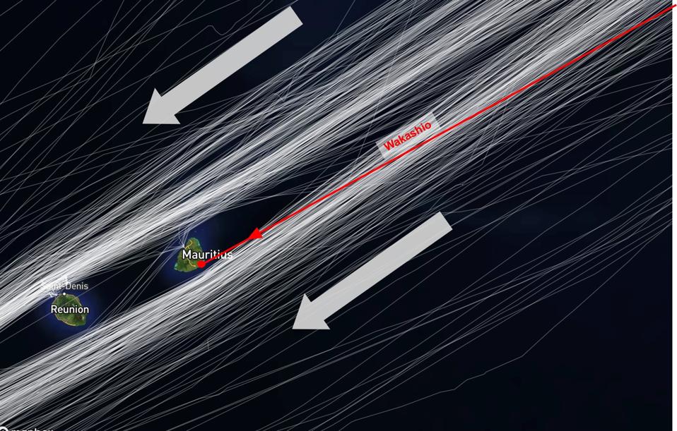
When zooming in a little closer and comparing the path of the Wakashio with other ships passing by Mauritius in July and August (1300 alone just heading in the Southerly direction as seen above), the Wakashio can be seen cutting across the busy shipping lane that takes the Southerly pass of Mauritius.
The Wakashio’s trajectory should have stood out like a sore thumb.
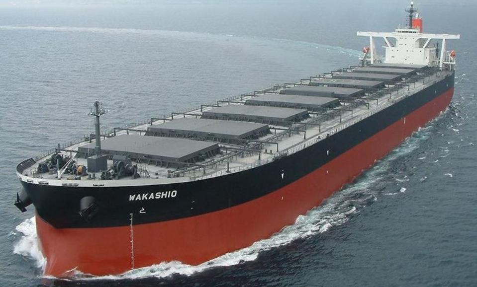
If someone can notice a bad driver cutting you up along a highway, other captains along these busy ship lanes would have clearly noticed a large iron ore vessel cutting across their bow too, moving from port (left) of the ship’s bridge to the starboard (right) as other captains’ vessels travel straight ahead. The massive 200,000 ton, 300 meter long (length of the Eiffel Tower) Wakashio iron ore bulk carrier with a height of 60 meters would have been travelling at a cruising speed of 11 knots, so likely to have been visible to many other other captains in the vicinity.
These captains should also be summoned (virtually) for the enquiry as witnesses. The ships that were in close proximity are easily identifiable by satellite.
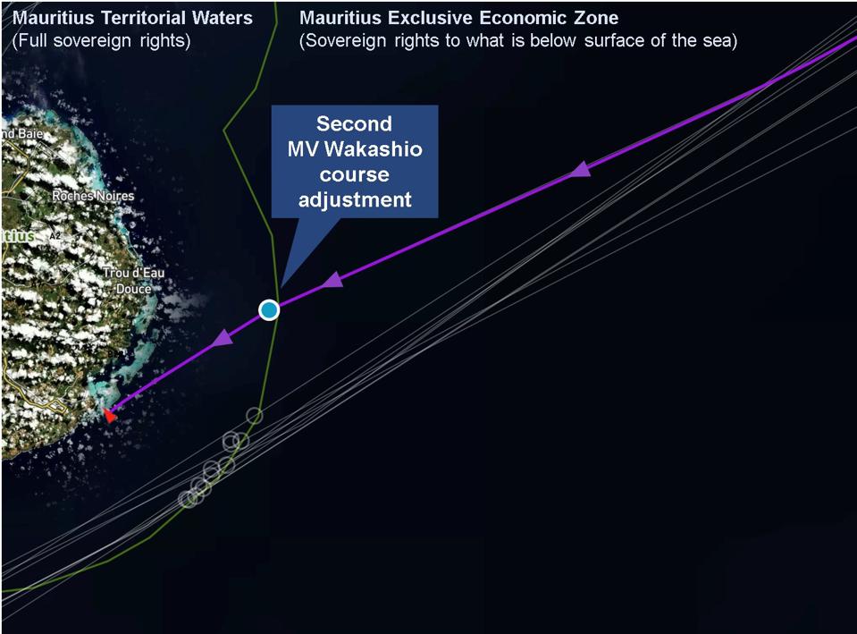
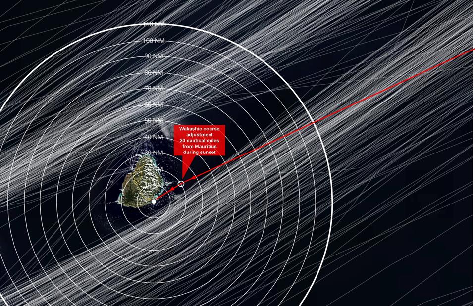
The Waksahio then makes a second, very minor, course adjustment around 20 nautical miles (23 miles) from the coast of Mauritius, just two hours before the collision. This is equally significant.
It was travelling at an even speed of 11 knots.
The sun was setting when the Wakashio collided with the coral reefs of Mauritius at 7.15pm on Sunday July 25. But at the time of this second course adjustment - which occurred in daylight less than two hours before the grounding - the coastline and mountains of Mauritius would have been clearly visible at 20 nautical miles given the clear skies that day.
Mauritius is not a low-lying island. As a former volcanic caldera, it has 91 peaks, with the tallest mountain rising 828 meters high, and the famous Lion Mountain that over looked the oil spill being 480 meters high. For comparison, sister island of Reunion which is 150 miles away can be seen from Mauritius, and drone footage of Mauritius’ East Coast show the coastal outline and mountains that would clearly have been visible just 23 miles away and for several hours prior from the bridge of the Wakashio.
Satellite analysis reveal that the Wakashio did not slow down or adjust course beyond a few degrees at this point.
The satellite analysis above also shows a handful of other ships passing close to Mauritius’ Territorial Seas over the summer. However, it is also important to note that while Mauritius had allowed 12 other vessels to travel within its territorial waters on the Southerly pass this summer of the 1300 that passed by, they were all beyond 10 Nautical Miles (not the five Nautical Miles that were claimed by the Panama Maritime Authorities about the Captain’s intended path).
Zooming out to see all 1300 vessels that passed by Mauritius, most were between 10 Nautical Miles and 40 Nautical Miles from where the Wakashio ended up on Mauritius’ coral reefs.
The trajectory of the Wakashio should have stood out, especially as it crossed the busy shipping lanes.
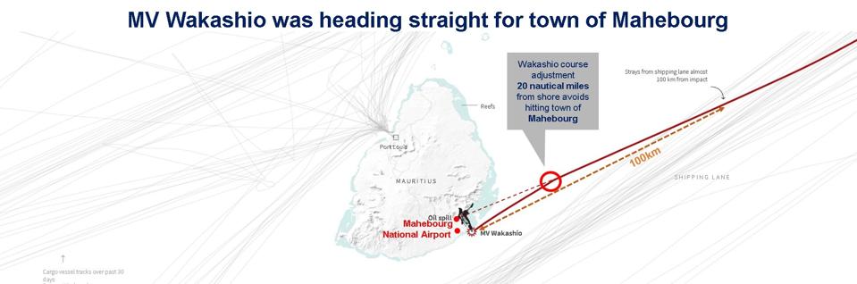
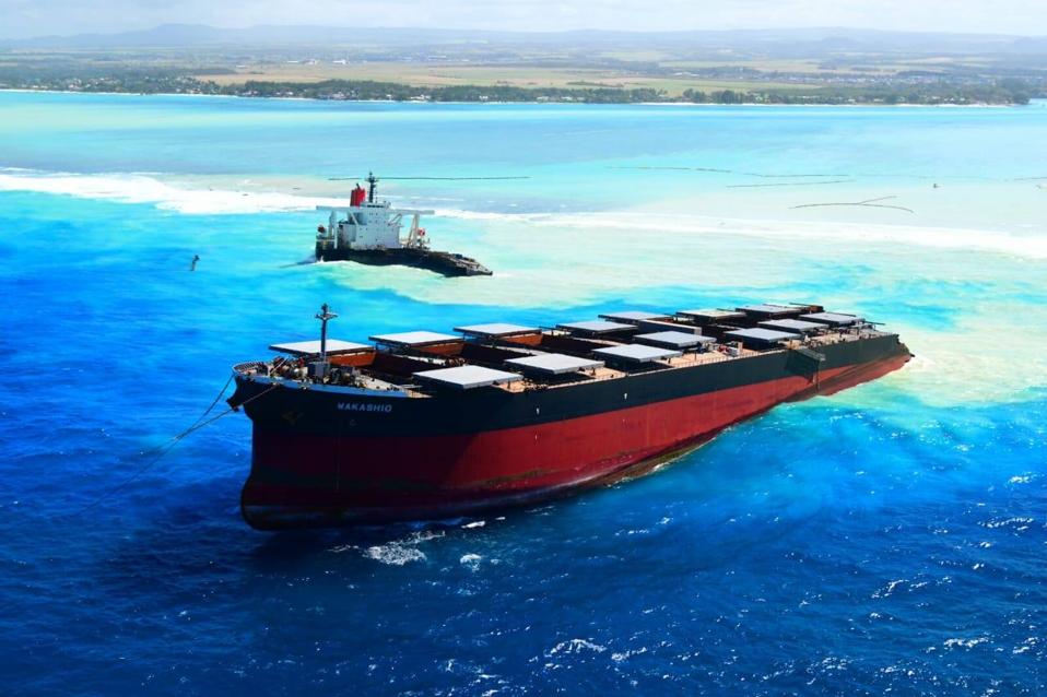
The significance of the second course adjustment becomes clear if you follow the intended trajectory of the Wakashio. Had it not made that final course adjustment, the Wakashio would have overrun the narrower coral boundary in that location and ended up in the Mahebourg channel and likely straight onto the mainland coast of Mauritius. This could have resulted in a spill five times worse, releasing all the 1 million gallons of oil it was carrying in the single hull vessel (rather than the 200,000 to 310,00 gallons - the final number has still not be revealed), with untold human health consequences in the towns and villages of 30,000 who live along that entire bay.
For perspective, the 200,000 ton vessel with over 1 million gallons of heavy, toxic ship oil was on a trajectory directly aimed at the town of Mahebourg for four straight days, until it changed course just 2 hours and 20 nautical miles out, when travelling at 11 knots. This was not a small incident.
According to Captain John Konrad from gCaptain who is licensed to skipper these Capesize vessels, such large iron ore bulk carriers like the Wakashio would take over 10 kilometers (34 ship lengths) to stop naturally. Their turning circles are usually several miles in diameter. Even in an emergency stop (called an emergency ‘crash stop’ maneuver with rudder pressed hard against one side, or an emergency ‘rudder cycling maneuver,’ with rudder alternating from side to side) this would take almost 2 kilometers (6 ship lengths) at best with the rudder thrown in hard and assuming nothing else has gone wrong. So for the 300m long 200,000 deadweight ton Wakashio, this would have caused significant damage to the rudder, which would be seen if the investigators were to image this part of the ship.
This is why imagery needs to be taken of all the Wakashio’s vital controls systems (like the rudder) as part of the incident investigation before the salvage teams arrive.
The crash investigation has to uncover whether the Wakashio was attempting to undertake an emergency maneuver but something was preventing it.
A natural question would be what happened to the coast defences of Mauritius.
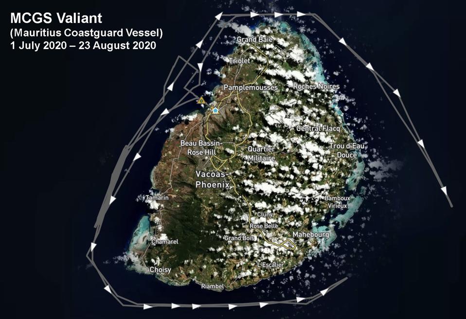
Satellite analysis of the patrol patterns of the major Coastguard assets of Mauritius reveal that they were mainly focused on patrolling the West Coast of Mauritius between July 1 and August 23.
More pertinently, Mauritius’ coastal defences were being provided by the Governments of India and Japan under a series of deals finalised in the past five years.
In the past five years, the Mauritian Government under Prime Minister Pravind Jugnauth took out almost $150 million in loans via the Export-Import Bank of India to finance and develop its maritime defences, in addition to $70 million in loans for the Mauritian Coastguard’s new Headquarters (’Project Trident’) and $1 billion in loans to build civilian infrastructure like the controversial Mauritian Tram System.
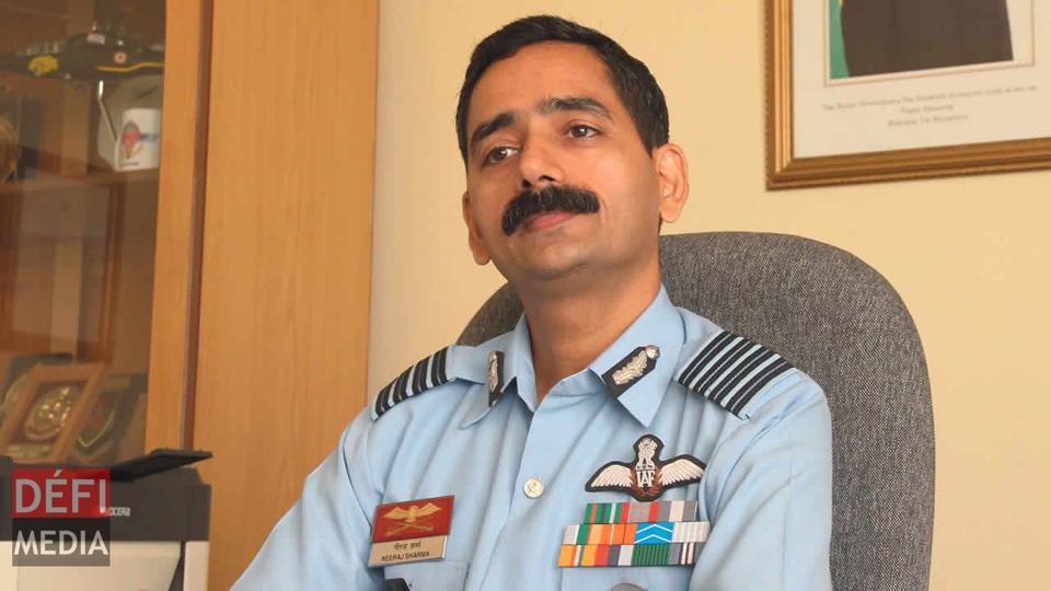
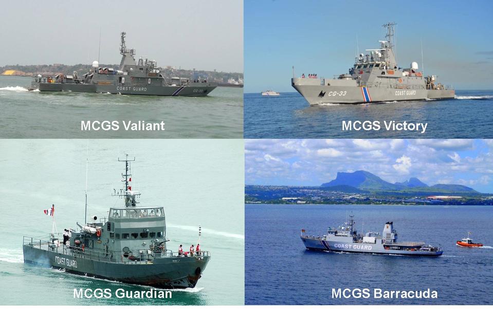
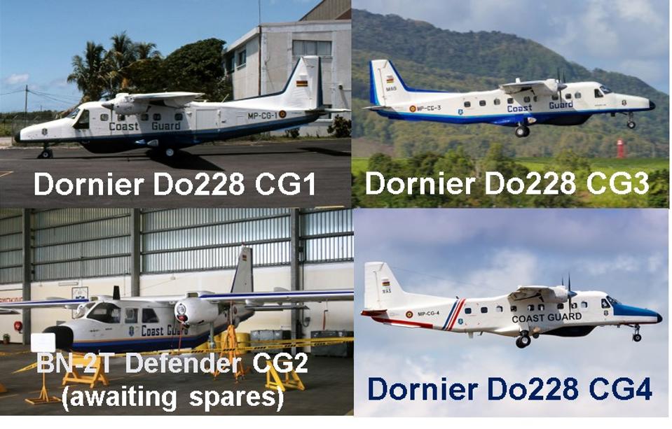
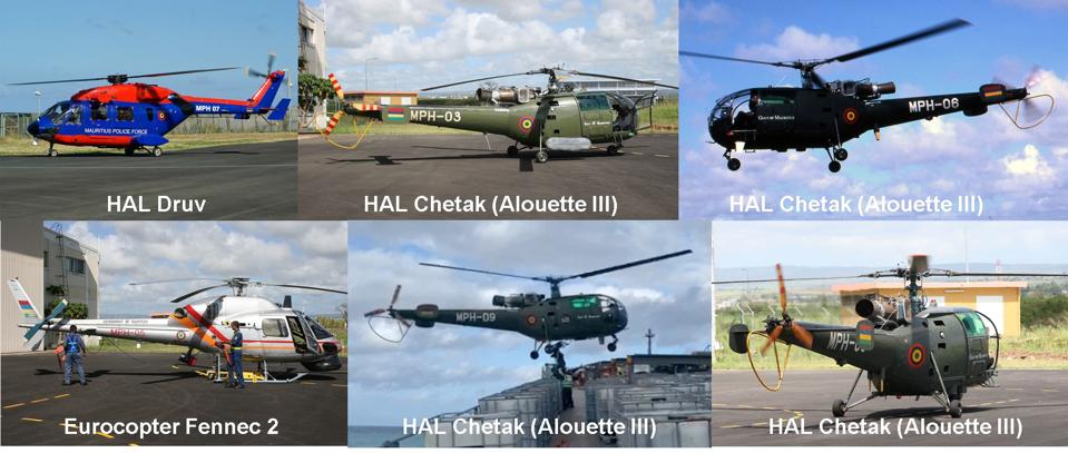
Under the policy of the current Mauritian Government over the past five years, Indian Officers have taken up senior positions within the Mauritius Police Force. While the Commissioner of the Mauritius Police Force is always a Mauritian national, the Head of the Mauritius Coastguard (NCG) is headed by an Indian Naval Officer, the Head of Mauritius’ Helicopter Squadron (PHS) is headed by an Indian Air Force Officer, the Head of Mauritius’ Air Squadron (MAS) is led by an Indian Air Force Officer, and the largest patrol vessels in the Mauritian Coastguard, such as the MCGS Barracuda, fall under actively serving Indian Naval Officers. As they are still part of the Indian military, they all continue to wear Indian uniforms while on secondment in Mauritius. The Indian head of the Mauritius Coastguard is yet to make a public appearance more than 70 days since the grounding of the Wakashio, attracting significant criticism from citizens in Mauritius angry for answers.
Under the complex set of India-Mauritius Defense Loan agreements, Mauritius acquired 21 air and sea vessels, almost all built in Government of India-owned facilities in the past five years. Details of these transactions are all available online.
These include:

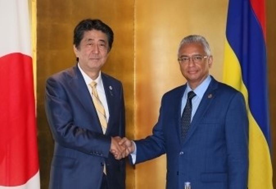
The total range of maritime security support from Japan was $15 million, including $12 million for a radar and $3 million (300m Japanese Yen) for ‘high speed patrol boats.’ It was a controversial agreement in Mauritius, with widespread protests and petitions against allowing the construction of a large fishing port and the Japanese fishing fleet given Japan’s stance on whaling and industrial overfishing in the Indian Ocean.
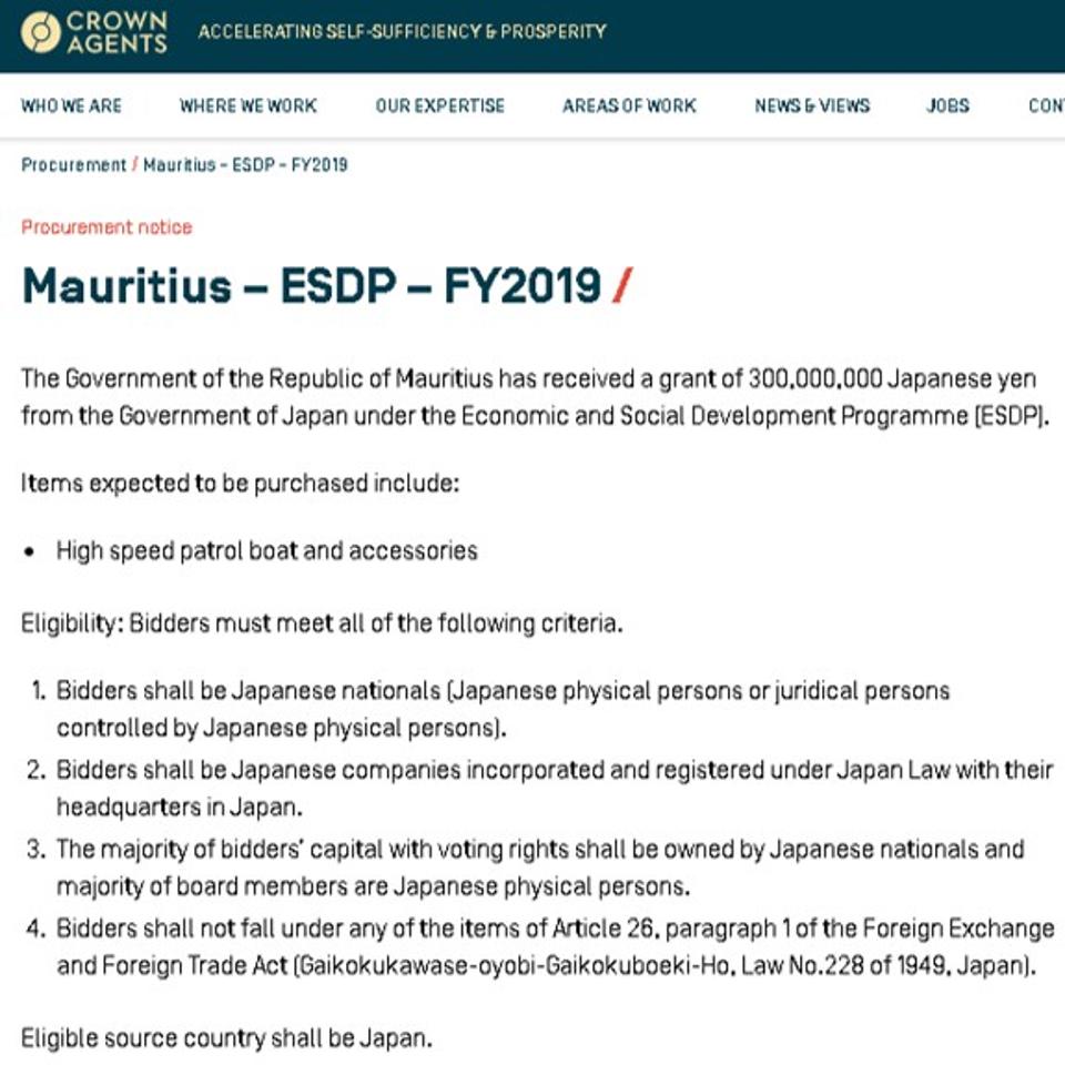
Again, the contract to build the Fast Patrol Boats was provided only to Japanese vessel owners registered in Japan (making one wonder whether Wakashio’s owner would have been eligible as all 11 of Nagashiki Shipping’s vessels were registered in Panama or the Marshall Islands under various subsidiary companies).
This follows a similar $7.1 million Indian Ocean maritime security agreement signed Between Japan and Seychelles last year (Japan-Seychelles Maritime Security Grant), that also included high speed patrol boats, operational equipment and unspecified ‘infrastructure,’ and also attracting Japanese companies into Seychelles for oil and gas exploration.
So when the Wakashio approached Mauritius, what happened to the Japanese Government’s maritime security arrangements, the fast interception boats and the radar systems that had been promised in the 2018 announcement?
So the failure to detect the arrival of the Japanese-built, owned, operated and insured Wakashio, was not just the failure of the Japanese ship operator and owners, but also the entire maritime security apparatus that the Governments of India and Japan were responsible for providing to Mauritius. Ouch.
The island nation has now been saddled with white elephant equipment and huge debt burdens it will have to dig its way out of. As well as hundreds of thousands of gallons of oil absorbed into its beaches as the cleanup science is politicised, local experts are marginalised and suspected coverups have eroded all trust with the local Government and international parties on the island.
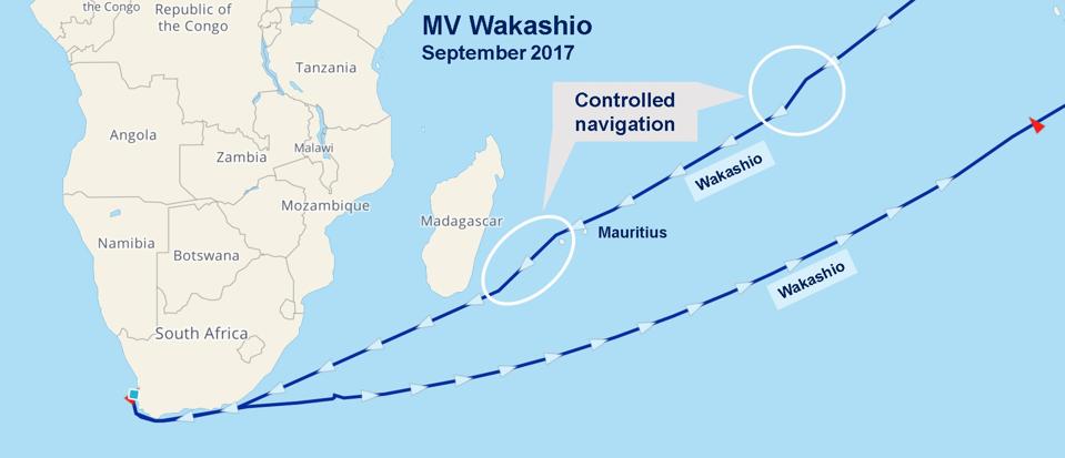
2020 was not the first time the Wakashio had made the voyage across the Indian Ocean. The previous time it had passed by Mauritius was three years ago in September 2017. On that occasion, it had sailed clear of the coastline of Mauritius, and had made two controlled manoeuvres, as it approached Madagascar.
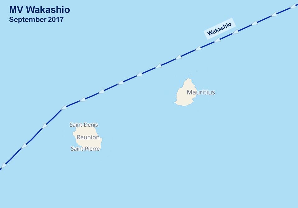
The Wakashio sailed safely past Mauritius, taking the Northern route during the last journey in 2017 and was several hundred miles South of Mauritius during the return leg.
There should have been electronic records and lessons for each leg of the journey so new captains are able to learn any navigation lessons.
Were travel routes not being catalogued and stored for future journeys? With digital systems, these solutions should be available at the click of a button.
An analysis of vessels travelling past Mauritius over this period reveals that keeping large vessels passing by Mauritius and Reunion island at least 40 Nautical Miles away should not disrupt the Indian Ocean shipping lanes.
Given the migration of whales from Antarctica to the waters of Mauritius during the Southern Hemisphere winter, there may also be a need to explore more slow steaming regulations to reduce the risk of whale strikes from these larger and larger vessels through the main whaling migratory paths.
Given these new revelations and the need to shift the focus of the investigation from the last moments of the Wakashio by Mauritius’ coast to the events four days previously, there will be some important questions to answer and pieces of evidence to collect.
The investigators should be taking images of the Engine Room (including all key components), the Rudder and Steering Control Systems, a full diagnostic of all Electronic Systems - especially the Electronic Chart Display and Information System, the ship’s Communication Systems.
The IMO has strict regulations about the competence of Accident Investigators and the procedures they should follow when conducting an investigation, including evidence gathering. With the eyes of the international community strongly on the Wakashio investigation, Panama, Japan and the other investigators from Mauritius could not afford to put a foot wrong, including omitting to collect any evidence or any evidence tampering. Deliberately sinking the front of the Wakashio and then mishandling the oil fingerprinting has already raised strong suspicions locally and internationally that something else is going on in Mauritius.
Satellites can reveal exactly where the rear of the vessel is on Mauritius’ coral reefs. The sediment pollution into the coral lagoons can be seen from space (lighter coloured sand-like sediment that is impeding photosynthesis and reproduction among the delicate soft corals).
There should be a negligible risk of igniting the remaining fuel on board the engine room of the vessel as diesel and ship oil mixed with seawater would be well below the flash point needed to start a fire risk in the engine room.
It is imperative that a thorough investigation takes place of the bridge and critical controls systems of the vessel before it is dismantled.
While the Wakashio will never sail again, it deserves something from the investigators that has been sorely lacking toward it for the past few months - transparency and professionalism.
Source: Forbes
China’s strategic use of ports, as well as its growing military presence in the maritime space in..
Four months since the major oil spill disaster, the ghost of the Wakashio continues to haunt the..
The Indian Navy has established the Indian Ocean Region Information Fusion Centre (IFC-IOR) near..
Press/media contact
Email Us
General Enquiries
Contact Us Here

© 2024 Dryad Global. All Rights Reserved